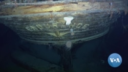
ການໄປສຳຫຼວດທີ່ນຳພາໂດຍທ່ານຈອນ ເຊຍສ໌ (John Shears) ນັກພູມສາດຄົ້ນຄວ້າກ່ຽວກັບຂົ້ວໂລກ ເມື່ອບໍ່ດົນມານີ້ ໄດ້ຄົ້ນພົບກຳປັ່ນເອນດົວແຣນສ໌ (Endurance) ຊຶ່ງເປັນເຮືອຫາຍສາບສູນໄປຂອງນັກສຳຫຼວດຊາວອັງກິດທີ່ມີ ຊື່ສຽງ, ທ່ານເອີນແນັສ ແຊັກເຄີລຕັນ (Ernest Shackleton), ຢູ່ທ້ອງພື້ນ ທະເລເວດແດລ (Weddell) ນອກຝັ່ງຂົ້ວໂລກໃຕ້.
ທ່ານຈອນ ເຊຍສ໌ (John Shears) ຜູ້ນຳພາຄະນະເດີນທາງໄປສຳຫຼວດເອນດົວແຣນສ໌ (Endurance22) ກ່າວຜ່ານ SKYPE ວ່າ:
"ເທັກໂນໂລຈີແມ່ນເປັນສາເຫດທີ່ພາໃຫ້ພວກເຮົາພົບເຫັນຊາກຫັກພັງຂອງກຳປັ່ນໃນຄັ້ງນີ້ໄດ້."
ເລີ້ມຕົ້ນດ້ວຍການໃຊ້ກ່ຳປັ່ນທີ່ທັນສະໄໝທີ່ສາມາດແລ່ນຜ່ານພື້ນທີ່ ທີ່ເປັນນ້ຳແຂງໄດ້… ແລະພາບຖ່າຍຈາກດາວທຽມທີ່ຊ່ວຍໃຫ້ຊອກຄົ້ນພື້ນທີ່ທົ່ວໄປບ່ອນທີ່ ໃນປີ 1915 ເປັນຄັ້ງສຸດທ້າຍທີ່ທ່ານແຊັກເຄີລຕັນ (Shackleton) ແລະ ລູກເຮືອ 27 ຄົນໄດ້ເຫັນກຳປັ່ນຄັ້ງສຸດທ້າຍ ກ່ອນມັນຈະຫາຍສາບສູນເຂົ້າໄປໃນນ້ຳທີ່ແຂງເປັນນ້ຳກ້ອນ. ພວກເຂົາເຈົ້າຖືກປ່ອຍໃຫ້ຢູ່ໃນເຮືອຊູຊີບ ແລະທັງຫມົດລອດຊີວິດມາໄດ້.
ທ່ານເຊຍສ໌ກ່າວຜ່ານ SKYPE ອີກວ່າ:
"ການມີຮູບພາບຈາກເຣດາຂອງດາວທຽມ ແມ່ນມີຄວາມສໍາຄັນຫຼາຍສໍາລັບພວກເຮົາ ເພື່ອໃຫ້ພວກເຮົາຮູ້ໄດ້ຢ່າງຊັດເຈນວ່າ ທະເລນ້ຳແຂງກໍາລັງເຮັດຫຍັງຢູ່ ແລະພວກເຮົາສາມາດວາງແຜນທິດທາງແລະເສັ້ນທາງເດີນຂອງ ພວກເຮົາໄດ້."
ມະນຸດບໍ່ສາມາດດຳນ້ຳໄດ້ຢ່າງປອດໄພ ຢູ່ໃນພື້ນທີ່ນັ້ນ. ສະນັ້ນ, ທີມງານຈຶ່ງໄດ້ສົ່ງຫຸ່ນຍົນໃຕ້ນໍ້າໄປກວດກາເບິ່ງພື້ນທະເລ ໂດຍໃຊ້ລະບົບກວດຫາສິ່ງຂອງໃຕ້ພື້ນນ້ຳດ້ວຍຄື້ນສຽງ ເພື່ອຄົ້ນຫາຄວາມຜິດປົກກະຕິ. ທີມງານໄດ້ມັດຫຸ່ນຍົນ ໃສ່ກັບເຮືອເພື່ອປ້ອງກັນບໍ່ໃຫ້ມັນສູນຫາຍໄປ.
ທ່ານນິໂກ ແວງຊັງ (Nico Vincent) ເປັນຜູ້ຈັດການໂຄງການຂອງການສຳຫລວດໃຕ້ພື້ນນ້ຳ ຫລື Subsea Expedition ຂອງທີມສຳຫລວດ Endurance. ທ່ານໂອ້ລົມກັບ VOA ຜ່ານທາງ Skype ວ່າ:
“ເມື່ອພວກເຮົາຖືກເອົາເຊື່ອມຕໍ່ໃສ່ກັນດ້ວຍສາຍໄຟ, ພວກເຮົາໄດ້ຮັບຂໍ້ມູນ ແລະ ການສົ່ງຂໍ້ຄວາມກັບມາຕະຫລອດເວລາຫາພື້ນດິນ. ແລະດັ່ງນັ້ນ ເຈົ້າກໍມີກ້ອງ ຖ່າຍຮູບ ແລະເຈົ້າຈະເຫັນສິ່ງທີ່ເຮືອນັ້ນໄດ້ເຫັນ.”
ເມື່ອເຄື່ອງກວດຫາສິ່ງຂອງດ້ວຍຄື້ນສຽງພົບບາງສິ່ງບາງຢ່າງ, ແສງໄຟ ແລະກ້ອງຖ່າຍຮູບຂອງຫຸ່ນຍົນກໍຈະຮຸ່ງຂຶ້ນ ແລະສົ່ງພາບໄປໃຫ້ທີມງານຢູ່ເທິງໜ້າດິນໃນທັນທີ. ນີ້ແມ່ນວິທີການທີ່ທີມງານໄດ້ຮູ້ເປັນຄັ້ງທໍາອິດ ກ່ຽວກັບກຳປັ່ນ Endurance.
ທ່ານແວງຊັງ, ຜູ້ຈັດການໂຄງການ Subsea ກ່າວຜ່ານ SKYPE ອີກວ່າ:
“ມັນເປັນຜົນສໍາເລັດ ແລະເປັນສິ່ງທີ່ພິສູດໃຫ້ໂລກຮູ້ໄດ້ແທ້ໆ ວ່າພວກເຮົາສາມາດເຮັດໄດ້ ແລະ ວ່າພວກເຮົາໄດ້ເຮັດແລ້ວ! ມັນສຳເລັດແລ້ວ!”
ຫຼາຍຄົນເຊື່ອວ່າການຄົ້ນພົບກຳປັ່ນ Endurance ເປັນການຄົ້ນພົບທີ່ສຳຄັນ ທີ່ສຸດ ນັບຕັ້ງແຕ່ມີການຄົ້ນພົບກຳປັ່ນໄທເທນິກ ເກືອບສີ່ສິບປີກ່ອນ ໃນປີ 1985.
ທ່ານດໍໂນລ ລາມອນທ໌ (Don Lamont) ເປັນປະທານຂອງມູນນິທິມູນເຊື້ອ ທາງທະເລ ຟອລກແລນສ໌ (Falklands Maritime Heritage Trust), ເຊິ່ງເຮັດໃຫ້ການສຳຫຼວດດັ່ງກ່າວສາມາດດຳເນີນການໄດ້.
ທ່ານໂອ້ລົມກັບວີໂອເອຜ່ານທາງ SKYPE ວ່າ:
“ຮູບພາບ ຂ້າພະເຈົ້າຄິດວ່າ ມັນໄດ້ເຮັດໃຫ້ເກີດຜົນກະທົບຢ່າງໃຫຍ່ຫຼວງ. ເພື່ອ ໃຫ້ເຫັນກຳປັ່ນລຳນີ້ໂຜ່ຂຶ້ນມາ ຫລັງຈາກມັນຢູ່ໃຕ້ພື້ນນ້ຳມາດົນນານ ໂດຍໃຫ້ ຢູ່ໃນສະພາບທີ່ດີ ໂດຍທີ່ມີເລື່ອງທີ່ໜ້າຟັງຕິດພັນຢູ່ກັບມັນເຊັ່ນນັ້ນ.” ແລະ ການຄົ້ນພົບໄດ້ເປີດໂອກາດໃຫຍ່ຫລວງໃຫ້ຄົນ.
ທ່ານລາມອນທ໌ກ່າວຜ່ານ SKYPE ອີກວ່າ:
"ຄວາມສາມາດເຮັດໄດ້ສໍາລັບຕົວແບບ 3D ສໍາລັບການເປັນຕົວແທນຂອງ ເທັກໂນໂລຈີໂຮໂລກຣາຟຟິກ (holographic) ແມ່ນແຕ່ ສໍາລັບກຳປັ່ນທີ່ເປັນແບບຈຳລອງຄືນ ຫລື replica. ວິດິໂອເກມ. ໃຫ້ວາດພາບເບິ່ງວ່າ ການໃສ່ແຫວ່ນ ຕາທີ່ສ່ອງເຫັນຕະຫລອດເວລາຈະເປັນແນວໃດ."
ທ່ານແຊັກເຄີລຕັນ (Shackleton) ໄດ້ເສຍຊີວິດໄປໃນ 100 ປີ ກ່ອນ ຢູ່ໃນມະຫາສະໝຸດແອນຕາກຕິກໃນຂະນະທີ່ ຢູ່ໃນທີມເດີນທາງສຳຫລວດອັນອື່ນ. ຍ້ອນວ່າມີເທັກໂນໂລຈີກຳປັ່ນ Endurance ຂອງທ່ານຈະຖືກນໍາກັບມາມີຊີວິດ ຊີວາຄືນອີກ ເພື່ອການສຶກສາ ແລະສ້າງແຮງບັນດານໃຈໃຫ້ແກ່ຊາວໂລກ.
ອ່ານຂ່າວນີ້ເພີ້ມເປັນພາສາອັງກິດຢູ່ລຸ່ມນີ້
Satellite imagery and underwater robotics are among the technologies that played a crucial role in the recent discovery of the Endurance, renowned explorer Ernest Shackleton’s ship that sank in frozen Antarctic waters in 1915. VOA’s Julie Taboh has more.
An expedition led by polar geographer John Shears recently discovered the Endurance, the lost ship of famed British explorer Ernest Shackleton, on the floor of the Weddell Sea off Antarctica.
John Shears, Endurance22 Expedition Leader via SKYPE:
“Technology was the reason that we found the wreck this time.”
Starting with a state-… and satellite imagery that helped locate the general area where, in 1915, Shackleton and his 27-member crew last saw the ship disappear into the ice. They left on lifeboats and all survived.
John Shears, Endurance22 Expedition Leader via SKYPE: “Having radar satellite imagery was very important to us so we knew exactly what the sea ice was doing, and we could plot our direction and route.”
Humans cannot dive safely in the area. So the team sent an underwater robot to scan the seabed, using sonar to look for anomalies. The team tethered the robot to the boat to prevent its loss.
Nico Vincent ((VAN-SAHN)) was the subsea project manager of the Endurance expedition. He spoke with VOA via Skype
Nico Vincent, Subsea Project Manager via SKYPE:
“As we were connected by wire, we got real-time data, feedback in [[to]] the surface. And so you have cameras, and you see what the vehicle is seeing.”
Once the sonar detected something, the robot’s lights and cameras turned on and sent images immediately to the surface. This is how the team got their first glimpse of the Endurance.
Nico Vincent, Subsea Project Manager via SKYPE:
“It was really an achievement and proof to the world that we can do it and that we made it! It’s done!”
Many believe the Endurance discovery is the most significant find since the discovery of the Titanic nearly forty years ago. [[in 1985.]]
Don Lamont ((LA-mont)) is chairman of the Falklands Maritime Heritage Trust, which enabled the expedition. He spoke with VOA via Skype:
Donald Lamont, Falklands Maritime Heritage Trust Chairman via SKYPE:
“The images I think made a huge impact. To see this ship emerge after so long under the water, in such good condition, with such stories attached to it.”
And the discovery opens a wealth of opportunities.
Donald Lamont, Falklands Maritime Heritage Trust Chairman via SKYPE:
“The potential for 3D models, for holographic representations, even for a replica ship. Video games. Imagine wearing those goggles of virtual reality.”
Shackleton died 100 years ago in the Antarctic while on another expedition. Thanks to technology, his Endurance will be brought back to life to educate and inspire the world.


