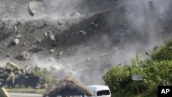
ມີຢ່າງໜ້ອຍ 4 ຄົນເສຍຊີວິດ ລຸນຫຼັງເກີດເຫດແຜ່ນດິນໄຫວຂະໜາດແຮງ ຢູ່ທາງພາກເໜືອຂອງຟີລິນປິນໃນວັນພຸດມື້ນີ້.
ອົງການສໍາຫຼວດທໍລະນີວິທະຍາຂອງສະຫະລັດກ່າວວ່າ ຢູ່ໃນແຂວງອາບຣາ (Abra) ເຊິ່ງຕັ້ງຢູ່ໃນເກາະໃຫຍ່ລູຊອນ (Luzon) ອັນເປັນຈຸດສູນກາງຂອງການສັ່ນສະເທືອນ ດ້ວຍຄວາມແຮງຂະໜາດ 7 ຈຸດເຊິ່ງໄດ້ເກີດຂຶ້ນເລິກລົງໄປຈາກໜ້າດິນ 10 ກິໂລແມັດ.
ເຈົ້າໜ້າທີ່ຂອງຟີລິບປິນກ່າວວ່າ ມີຢ່າງໜ້ອຍ 44 ຄົນໄດ້ຮັບບາດເຈັບຈາກໄພພິບັດດັ່ງກ່າວນີ້.
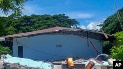
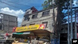
ເຈົ້າໜ້າທີ່ກ່າວວ່າ ອາຄານຫຼາຍສິບຫຼັງໄດ້ພັງລົງມາ ຫຼືໄດ້ຮັບຄວາມເສຍຫາຍຢ່າງຮຸນແຮງທົ່ວແຂວງອາບຣາ. ມີຮູບພາບຈໍານວນຫຼາຍທີ່ຖືກໂພສລົງເຟສບຸກສ່ວນໂຕຂອງຮອງເຈົ້າແຂວງອາບຣາ ທ່ານນາງຈອຍ ເບີໂນສ (Joy Bernos) ທີ່ເປີດເຜີຍໃຫ້ເຫັນປະຊາຊົນ ແລະແພດໝໍພາກັນຢືນຢູ່ດ້ານນອກຂອງໂຮງໝໍທີ່ມີຮູຂະໜາດໃຫຍ່ຢູ່ດ້ານໜ້າຂອງອາຄານໂຮງໝໍ.
ແຮງສັ່ນສະເທືອນຈາກແຜ່ນດິນໄຫວ ສາມາດຮູ້ສຶກໄດ້ໄກຮອດນະຄອນຫຼວງມະນີລາ, ເຊິ່ງຕັ້ງຫ່າງອອກໄປທາງທິດໃຕ້ປະມານ 300 ກິໂລແມັດຈາກສູນກາງຂອງແຜ່ນດິນໄຫວ.
ປະທານາທິບໍດີ ເຟີດິນານ ມາໂກສ ຈູເນຍ ກ່າວກັບບັນດານັກຂ່າວໃນການຖະແຫຼງຂ່າວວ່າ ແຜ່ນດິນໄຫວດັ່ງກ່າວນັ້ນ “ແມ່ນມີຄວາມຮຸນແຮງຫຼາຍ” ແລະເຮັດໃຫ້ໂຄມໄຟຢູ່ໃນຫ້ອງການຂອງຂ້າພະເຈົ້າແກວ່ງໄກວໄປມາ. ປະທານາທິບໍ ດີມາໂກສ ກ່າວວ່າ ທ່ານຈະບິນໄປແຂວງອາບຣາ ໃນວັນພະຫັດມື້ອື່ນນີ້ ເພື່ອກວດກາເບິ່ງຄວາມເສຍຫາຍ.
ປະເທດໝູ່ເກາະ ໃນເອເຊຍຕາເວັນອອກສຽງໃຕ້ແຫ່ງນີ້ ຕັ້ງຢູ່ໃນຂົງເຂດ “ວົງແຫວນໄຟ” ສົ່ງຜົນໃຫ້ມີເຫດການແຜ່ນດິນໄຫວຢ່າງຕໍ່ເນື່ອງ, ເຊິ່ງເປັນກຸ່ມພູໄຟ ແລະຮອຍແຕກຂອງແຜ່ນດິນໄຫວ ທີ່ກວມເອົາບໍລິເວນຂະໜາດໃຫຍ່ອ້ອມຮອບມະຫາສະໝຸດປາຊີຟິກແຫ່ງນີ້. ນອກຈາກນັ້ນ, ປະເທດຟີລິບປິນ ຍັງໄດ້ຖືກທໍາລາຍຈາກພາຍຸຕ່າງໆ ແລະໄຕ້ຝຸ່ນອີກປະມານ 20 ຄັ້ງ ໃນແຕ່ລະປີອີກດ້ວຍ, ອັນໄດ້ເຮັດໃຫ້ເປັນນຶ່ງປະເທດທີ່ມີຄວາມສ່ຽງ ກ່ຽວກັບໄພພິບັດຫຼາຍທີ່ສຸດໃນບັນດາປະເທດຕ່າງໆໃນໂລກ.
At least four people were killed Wednesday after a strong earthquake struck the northern Philippines.
The U.S. Geological Survey says the province of Abra on the main island of Luzon was the epicenter of a 7 magnitude quake, which struck at a shallow depth of 10 kilometers.
Philippine authorities say at least 44 people were injured in the disaster.
Authorities say dozens of buildings collapsed or were severely damaged across Abra province. Photos posted on her Facebook account by Abra vice governor Joy Bernos show residents and staff standing outside a hospital that was left with a gaping hole in the front of the building.
Shockwaves from the quake were felt as far away as the capital, Manila, located about 300 kilometers south of the epicenter.
President Ferdinand Marcos, Jr. told reporters at a news conference that the quake “was very strong” and caused the chandeliers in his office to sway. President Marcos said he will fly to Abras province Thursday to inspect the damage.
The Southeast Asian archipelago lies in the seismically active Pacific “Ring of Fire” region, a band of volcanoes and seismic fault lines that circles a large area of the Pacific Ocean. The Philippines is also battered annually by about 20 storms and typhoons, making it one of the world’s most disaster-prone countries.