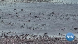
ມັນຄ້າຍຄືກັບຮ້ານອາຫານທີ່ເປີດຂຶ້ນມາໂລດ ດິນທາມຫລືພື້ນທີ່ຊຸ່ມຊົ່ວຄາວໃນ ຮ່ອມພູພາກກາງຂອງລັດຄາລິຟໍເນຍ ຖືກສ້າງຂຶ້ນໃນເວລາ ແລະສະຖານທີ່ທີ່ ເຫມາະສົມອີ່ຫລີ ເພື່ອຮັບໃຊ້ນົກທີ່ ເຄື່ອນຍ້າຍມາໂດຍການເດີນທາງທີ່ຍາວໄກ.
ທ່ານຣອດ ແຄລຊີ (Rodd Kelsey) ຈາກອົງການອະນຸລັກທຳມະຊາດ ຫລື Nature Conservancy ຊຶ່ງເປັນກຸ່ມອະນຸລັກສິ່ງແວດລ້ອມກ່າວວ່າ:
“ເມື່ອສອງຮ້ອຍປີກ່ອນ ຖ້າເຈົ້າເປັນນົກທີ່ບິນຢູ່ເທິງພູມສັນຖານອັນນີ້ ສິ່ງທີ່ທ່ານ ຈະໄດ້ເຫັນແມ່ນພາບສະຫລັບກັນ ຫລື mosaic ລະຫວ່າງດິນທາມ ແລະ ທົ່ງຫຍ້າ ທີ່ສະຫນອງແມງໄມ້ ແລະອາຫານອື່ນໆ ທີ່ອຸດົມສົມບູນ ໃຫ້ແກ່ທ່ານກິນ. ຕັ້ງແຕ່ນັ້ນມາ, ສິ່ງທີ່ພວກເຮົາໄດ້ເຫັນແມ່ນພູມສັນຖານອັນນີ້ໄດ້ຫັນໄປສູ່ ການ ກະສິກໍາເກືອບວ່າ ແຕ່ຝາກຳແພງກ້ຳນັ້ນ ຮອດຝາກໍາແພງກ້ຳນີ້."
ຈໍານວນນົກໄດ້ຫຼຸດລົງຢ່າງຫຼວງຫຼາຍ ຍ້ອນການຂາດອາຫານ ແລະທີ່ຢູ່ອາໄສ ໃນລະຫວ່າງການເຄື່ອນ ຍ້າຍທີ່ຍາວໄກເຖິງ 11,000 ກິໂລແມັດ.
ປົກກະຕິ ທົ່ງນານີ້ຈະແຫ້ງແລ້ງໃນຊ່ວງເວລານີ້ຂອງປີ. ໂຄງການອະນຸລັກທີ່ມີການປະດິດສ້າງ ກຳລັງຈ່າຍເງິນໃຫ້ຊາວກະສິກອນ ເພື່ອເຮັດທົ່ງນາ ໃຫ້ມີນໍ້າຖ້ວມເປັນເວລາສອງສາມອາທິດຕໍ່ຄັ້ງ ເພື່ອສະຫນອງທີ່ຢູ່ອາໄສ ແລະອາຫານ. ການກໍານົດເວລາ ແລະບ່ອນທີ່ຈະເຮັດໃຫ້ມີນໍ້າຖ້ວມ ແມ່ນສໍາຄັນທີ່ສຸດຕໍ່ຜົນສໍາເລັດຂອງໂຄງການ. ນີ້ແມ່ນເປັນບ່ອນທີ່ແອັບພລີເຄຊັນອີ-ເບີດ (eBird) ເຂົ້າມາ. ມັນເປັນແອັບພລີເຄຊັນທີ່ຟຣີ, ບໍ່ເສຍຄ່າ ທີ່ໃຊ້ໂດຍພວກນັກຊົມນົກ ເພື່ອບັນທຶກທີວທັດທຳມະຊາດ.
ທ່ານຣອດ ແຄລຊີ (Rodd Kelsey) ຈາກອົງການ Nature Conservancy ກ່າວວ່າ: "ແລະການສັງເກດການທັງໝົດເຫຼົ່ານັ້ນ ສາມາດຖືກນໍາໃຊ້ເພື່ອເຮັດການຄາດ ຄະເນເຖິງບ່ອນທີ່ນົກຈະມາຢູ່ຢ່າງອຸດົມສົມບູນທີ່ສຸດ, ໃນຊ່ວງເວລາໃດ ຂອງປີ."
ການນໍາໃຊ້ແບບຂອງ eBird ສົມທົບກັບຂໍ້ມູນທາງດາວທຽມທີ່ຄາດຄະເນວ່າ ບ່ອນທີ່ມີນ້ໍາເກີດຂຶ້ນຕາມທໍາ ມະຊາດ, ສະມາຊິກໃນທີມສາມາດກໍານົດ ຊ່ອງ ຫວ່າງ ແລະກໍານົດວ່າ ທົ່ງແຫ່ງໃດທີ່ຄິດວ່າ ເໝາະສົມທີ່ສຸດທີ່ຈະຖືກນ້ໍາຖ້ວມ.
ຟາມມອນເທນາ (Montna) ໄດ້ເຮັດໃຫ້ນໍ້າຖ້ວມບາງສ່ວນຂອງເນື້ອທີ່ທັງໝົດ 162 ເຮັກຕາຂອງຕົນສໍາລັບໂຄງການນີ້.
ທ່ານຈອນ ມັງເກີ (Jon Munger), ຜູ້ຈັດການຟາມດັ່ງກ່າວບອກວ່າ: "ນົກກະສາໜ້າຂາວ, ມັນແມ່ນນົກຊະນິດນຶ່ງທີ່ເມື່ອ 21 ປີກ່ອນ ຂ້ອຍໄດ້ເຫັນ ໂຕນຶ່ງ ຫຼືສອງໂຕ ແຕ່ດຽວນີ້ຂ້ອຍເຫັນມັນເປັນຝູງ ແລະ ມີຫຼາຍພັນໂຕ ຢູ່ໃນຟາມນັ້ນ."
ຜົນສຳເລັດຂອງໂຄງການດັ່ງກ່າວໄດ້ຊຸກຍູ້ໃຫ້ກຸ່ມອຸດສາຫະກຳຜະລິດເຂົ້າ ໃຫ້ເລີ້ມເຮັດໂຄງການຂອງຕົນເອງ ທີ່ເຮັດວຽກຮ່ວມກັນກັບຊາວກະສິກອນ.
ອ່ານລາຍງານນີ້ເພີ້ມເປັນພາສາອັງກິດຢູ່ລຸ່ມນີ້:
Guided by data from a bird-watching app, conservationists and farmers are creating instant wetlands for birds traveling thousands of miles. Matt Dibble has the story.
It’s like a pop-up restaurant, this temporary wetland in California’s Central Valley, created at just the right time and place to serve migrating birds on a very long journey.
Rodd Kelsey of the conservation group The Nature Conservancy.
“Two hundred years ago if you were a bird flying over this landscape, what you would have seen is a mosaic of wetlands and grasslands that provided abundant bugs and other food for you to eat. Since then, what we've seen is this landscape has turned into a patchwork of almost wall-to-wall agriculture.”
Bird populations have dropped dramatically from lack of food and habitat during migrations stretching up to 11,000 kilometers.
This rice field would normally be dry at this time of year. An innovative conservation program is paying farmers to flood fields for a few weeks at a time to provide habitat and food.
Determining when and where to flood fields is critical to the program’s success.
This is where eBird comes in. It’s a free app used by birdwatchers to record sightings.
Rodd Kelsey, The Nature Conservancy:
“And all of those observations can be used to make predictions of where birds will be most abundant, at which times of the year.”
Using the eBird models, combined with satellite data predicting where water naturally occurs, team members can identify gaps and determine which fields make the most sense to flood.
Montna Farms has flooded some of its 162 hectares for the program.
Jon Munger is manager of the farm:
Jon Munger, Montna Farms
“White-faced ibis, it was a bird that maybe 21 years ago I'd see one or two of them, now I'm seeing flocks and thousands of them on the farm.”
The project’s success has spurred a rice industry group to launch its own program working with farmers.


